KJIPUKTUK (Halifax) – A wonderful new website explores the deep connection between the Mi'kmaq people and the landscape of Mi'kma'ki, the place the Mi'kmaq have called home since time began and never ceded.
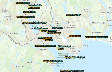
Central to the website is an interactive map showing more than 700 Mi'kmaw place names throughout Nova Scotia. Clicking on the place name allows you to explore origin and meaning of the name.
“The Mi’kmaq sprouted or emerged from this landscape and nowhere else; their cultural memory resides here…,” the website explains.
Against great odds, knowledge of the traditional names has survived. The map reflects five years of research of historical documents and interviews with Mi'kmaw elders and other knowledge holders.
Most Halifax Media Co-op readers know that the place we now call Halifax is also known as Kjipuktuk, meaning 'great harbour'.
Now you can find out that a place on the Dartmouth side of the harbour was called Punamu’kwati’jk, meaning 'at the tomcod (a type of cod fish) place'. Mill Cove, along the Bedford Highway, now infilled and appropriated by Sobey's, once went by the name Kitpukusisek, 'at the eagle's nest'.
Where today is Lower Sackville there once was a place people called Alusulue’katik, meaning 'at the measles place'. Infectious diseases carried by Europeans in the eighteenth century devastated the Mi'kmaq population. This must have been a place where one such calamity occurred.
Dr. Trudy Sable, Director of the Office of Aboriginal and Northern Research, Saint Mary’s University (SMU) and Mi'kmaw linguist Dr. Bernie Francis spearheaded the project, aided by a team of Mi'kmaw university students who conducted many of the interviews.
See also: Sunday book review: The language of this land, Mi'kma'ki
Follow Robert DeVet on Twitter


