Through an Access to Information request, the Halifax Media Co-op has obtained a map of all glyphosate applications on Crown Land in the province of New Brunswick, between 2005 and 2014.
While our initial request from New Brunswick's Department of Natural Resources (DNR) was for a map of all Crown Lands that had received a glyphosate application since the inception of the herbicide application program in the 1980s, we have been informed that “a map containing all data since the inception of the program does not exist.”
Whether New Brunswick DNR does not have this information on-hand at all, or whether they have simply not tabulated the information into a map format is not clear. In any case, approximately 20 years of information related to glyphosate applications on Crown Lands in New Brunswick is missing from the attached map.
Glyphosate applications on Crown Lands in New Brunswick – estimated by the province to be in the range of 12,000 to 14,000 litres annually - are largely undertaken in order to kill off plant species that might potentially compete with softwood trees, which themselves are used as fodder for the province's highly-subsidized pulp and paper industry.
Glyphosate applications, on forests and more often upon genetically-engineered food crops, have come under heavy criticism for their suggested links to human health impacts. In communications with provincial governmental representatives, throughout 2014 and 2015, whistle blower New Brunswick deer biologist Rod Cumberland noted that research into glyphosates differs greatly between European and North American studies.
In Europe, claimed Cumberland, studies into glyphosate applications are often far more 'long term' in scope, and study the effects of glyphosate applications under 'real time' scenarios. In North America, where the reach and financial heft of glyphosate's main producer, Monsanto, is more strongly felt amongst the scientific community, Cumberland asserted that glyphosate-related studies are narrowly focused and limited in scope.
Cumberland's claims were bolstered earlier in 2015 by the World Health Organization, which classified glyphosate as a 'probable' human carcinogen. As a result, numerous private vendors across Europe reacted by removing glyphosate products from their store shelves. Monsanto reacted as expected, disagreeing with the 'probable carcinogenic' link, citing scientific and regulatory precedence that found glyphosate to be safe.
While Cumberland and others continue to seek a ban on glyphosate applications in New Brunswick, the provincial government does not appear to have any plans to curtail its subsidization of glyphosate spraying on Crown Lands.
Documents that we earlier obtained show, likely only to a very small degree, the influence that industrial forestry players in New Brunswick have on setting the province's tree cutting agenda. Glyphosate applications are, from a 'bottom line' perspective, good for the pulp and paper industry; chemical applications are a cheap alternative to obtaining uniform softwood stands when compared to employing dozens of individuals in more labour-intensive 'tree spacing' methods.
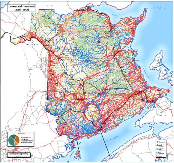
The attached DNR map is of interest – and perhaps troubling - for a variety of reasons. Firstly, the lack of information related to pre-2005 applications on Crown Lands is noticeable.
The only information related to pre-2005 chemical applications available appears to be that 40% of the pre-2005 natural regeneration, clear cut, area (shown as green and unshaded in the legend) received a “PCT” or Previous Chemical Treatment. The green areas of the map are not divided into shaded and unshaded areas, so basically this might be anywhere on the map coloured green.
As for the 'planted' orange areas on the map, 79% of these areas (shaded) received a herbicide treatment. Again, the orange areas of the map are not divided into shaded and unshaded areas, so these areas might be anywhere coloured orange.
The concentration of orange zones, that is to say replanted areas that would likely be softwood tree farms that have received glyphosate applications in the last decade, are also concentrated more highly in particular areas of the province. For example, the map shows a high degree of concentration of orange coloration northwest of Mount Carleton Provincial Park, between St Quentin and Kedgwick, as well as just north of Havelock, in the southeast of the province. These concentrations of glyphosate applications do some discredit to the provincial DNR mantra that 'under 1% of Crown Land is sprayed with glyphosate per year'.
While geographically this may be the case, some regions of the province have literally been covered in glyphosate applications over the last decade.
The following map was obtained through an Access to Information:
New Brunswick Crown Land chemical treatments - 2005 - 2014 by Miles Howe